Sunday 11 September 2016

Walk 234

Whitby to Scarborough 22miles

So this was the last day of my journey, it had taken 6 years and 10 months to get this far. I had stayed in 150+ bed and breakfasts, I bought and wore 8 pairs of boots/shoes but only worn out 2 of those pairs (the rest are still going or have been binned due to blisters!), 3 different backpacks, numerous pairs of socks/hats/gloves/sunglasses and countless Ice Creams!!!!! A lot has happened in nearly 7 years, relatives have passed away, old friends have come back into my life and then promptly reversed back out of my life, my daughter was in secondary school when I started and then 6th form college and now University.

                     Suprisingly I woke up with the usual feeling that today was just another days walk, I had expected something else I guess, but what I had expected who knows?
                     I made my way out of Whitby at 8.30am and it was a completely different place on this quiet Sunday morning, just lovely.
Whitby Abbey
The weather was fantastic I couldn't have ordered a better forecast for the day.
                I chose what I thought was the correct route out of town but then it turned into a dead end!! lost again,  I thought somethings don't change!!, eventually I managed to find my way to the top of the hill and what a view! The magnificent Whitby Abbey was sitting proudly at the top.
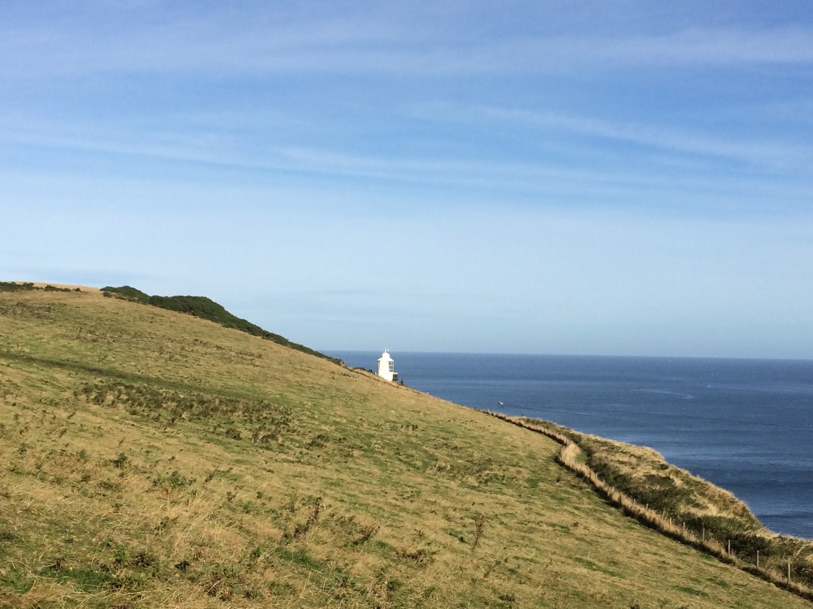
                I had been warned that the walking was going to be tough today as there are a lot of hills and valleys between here and Scarborough. I stopped/got lost again! at the lighthouse at Beacon Hill.
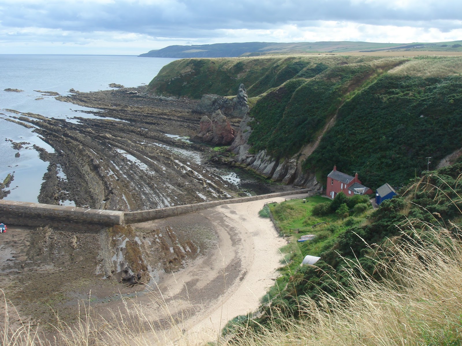
The walking was still pretty easy at this point and as I made my way along to Robin Hood's Bay I did start to think what all the fuss was about......but then it happened......I looked at my map to find the route out of Robin Hood's Bay and then I realised that I had to go down the hill to the sea!!! If you haven't been to Robin Hoods Bay before, then you need to brace yourself for a steep climb/decent, its a real doozy!!! Once I had reached the bottom I walked along the front and started to climb back up the other end of the bay....what goes down must come back up!!!
Robin Hood's Bay

I stopped at the top to take a breather and a photo at the same time.  Very soon Boggle Hole reared its head and once again I was plunged downwards to sea level and then back out the other side.  This happened a couple of more times (there are 6 between Whitby and Ravenscar!) until I arrived at the bottom of a ludicrously big hill just before Ravenscar, by the time I got to the summit of the hill I was very hungry and I have to say there isn't much in Ravenscar other than a hotel and a NT café, so I chose the Hotel which did me a very nice sandwich indeed!!

The walking became a bit easier after Ravenscar in so much that the hills/valleys were a lot less steep!! I carried on past Hayburn Wyke and onto Rodger Trod.  My eyes were firmly fixed on the horizon constantly scanning it for any sign on the Castle at Scarborough, finally the path took a bit of a dip and I caught sight of it amongst the trees in front of me, I was nearly finished after a little under 7 years I couldn't quite believe it!!.  I carried on past Cloughton Wyke, Hundale Point and Sailors Grave before I made the final decent onto the flat promenade at Scalby Mills, I stopped at the pub in Scalby Mills for a drink just (I think) to eek out the end of the walk for the last few minutes as it was less than a mile to go! 
                The North Bay promenade was busy on this fine Sunday afternoon and I walked purposely on to my finish point at the Corner Café. There was no one at the end to congratulate me which is exactly how I wanted it to be and how it was at the start of my walk on 18th November 2009 when I slipped out of the house on that wet Wednesday morning, I sat down on a bench at the Corner Café in between 2 elderly ladies and they paid me no heed, little did they know that I had just walked 5000 miles :)

                                             THE END


Thank you to my family and friends who all supported me during this journey and especially to my wife who let me disappear for many weeks on end.

Saturday 10 September 2016

Walk 233

Skinningrove to Whitby  23miles

I could of binned my maps now that I was on the well signposted Cleveland Way, this long distance path would take me all the way to my finish at Scarborough in 2 days time.
Runswick Bay
 The hills and valleys came thick and fast and my first stop of the day was at Staithes. Staithes was holding its annual arts festival where over 60 houses open their front doors to let people wander around them looking at the art that they have created, I find it amazing that in such a small place there are so many artists.  I unfortunately didn't stop to browse at any of the artwork, again, maybe another day.
Staithes

Staithes itself is one of the most stunning little coastal villages I have walked through, it reminded me very much of Cornwall.
               The path continued up and down through Port Mulgrave, Rushwick Bay and Scratch Alley before arriving at the aptly named village of Sandsend. Sandsend is aptly named due to the fact that the beach from Whitby finishes at Sandsend!  I now had the opportunity to walk along the 3 mile beach all the way to Whitby which I relished as the tide was well on its way out.  Once I reached Whitby I had a real shock as I turned the corner to walk down the high street, there were people everywhere!! its a real shock to the system when day in day out you hardly see a soul and then you are faced with a Wall of people!!!! I had arrived in Whitby during "pirate weekend" hence the reason it was so busy.
Staithes
Accommodation: Air Bnb. I had a whole house to myself so I put my feet up and relaxed!!!! £38.00 RO

Friday 9 September 2016

Walk 232

Seaton Carew to Skinningrove 23miles

After a very average nights sleep I went in search of a place in Seaton Carew to have breakfast as the hotel I was stopping in was bed only, I walked along the seafront and there was nothing open I fortunately had an "emergency banana".  I glumly ate my banana as I walked out of Seaton Carew, the wind had got up overnight and this was significant to me as I would be crossing the River Tees today via the transporter bridge, if the wind was too strong then the bridge couldn't operate and I would be faced with a very long walk into Middlesborough and back out again.
              There is only one road from Seaton Carew to Middlesborough and its a fast one! There is a path for about a mile and then its a case of diving in the bushes when the lorries come past.  Middlesborough is very industrial and you can smell it before you actually arrive such is the concentration of Steel Works/Chemical Works.
                As I walked along the busy road towards the Transporter Bridge I kept squinting to see if the  gondola was running along the top of the bridge, eventually I saw something move and my heart lifted! I picked up the pace and made my way around to the departure point.
Transporter Bridge
This was my second Transporter Bridge of my journey, the first one was in Newport in Wales. I love the whole concept of the bridge and it was a shame that I was the only passenger on the journey across the Tees, but it was 60p well spent! I chatted to one of the men who operate the gondola and he informed me that there are 6 transporter bridges in the world so maybe another project for me in the future would be to visit all of them!
                      Not long after the bridge I picked up the Teesside way Path, this runs from Dufton in Cumbria to South Gare on the north sea coast a total distance of 92 miles.  This part of Teesside way I found myself on ran parallel with the railway line most of the way to the sea, however there was a problem when I reached a fence barring the way.
You shall not pass!

 I had been warned by 2 different people that the route was blocked but I decided to ignore both of them! I ducked under the fence to the right of the blockage and walked along side the path until I found a way over the fence, it was pretty easy in the end and the path was clear all the way to the road.  At the junction of the road/path there was a council sign saying why the path was closed, obviously the sign at the end I entered the path on had been removed.
             I carried on along the Teesside way until I reached the signpost that marks the start/finish of the walk.
Teesside Way Start/finish
Its a nice start/finish point because the post is sprayed silver and so are the walking shoes/seat and backpack a good place for a rest :)
                      I continued on towards Redcar and I must say I was pleasantly supprised on how nice the seafront was, here are a few pictures.


I was able to take the beach route to Saltburn,  I had arranged with some family friends to meet me on the way, this was another first for me as I had company(other than coast walkers!) for one of my walks!

Saltburn


 I had been looking forward to Saltburn and its superb funicular railway.  I stopped for an hour and drank tea with my friends, but all too soon I had to wave them goodbye. I had now picked up the Cleveland Way and the first hill was a big un! I huffed and puffed my way to the top of the hill and then carried on along the cliff tops before dropping down into the lovely bay at Skinningrove. A very varied and rollercoaster days walking.
Skinningrove


Accommodation: Moonfleet, 1 The Square. Skinningrove. £60.00 BnB. A really nice place to stay and the host was fantastic. Like I always say " you get what you pay for"

Thursday 8 September 2016

Walk 231

Sunderland to Seaton Carew 29miles

A day that started with what I thought was 23miles but turned into a leg busting 29 miles, at least this would be the last of the big cock up days!
As I walked across the bridge over the river Wear I noticed some new signage and that was the ECP.  The English Coast Path has been in the planning stages for many years and at last some progress is being made to way mark all of the English Coast, the section I was walking along goes from Sunderland to Middlesborough.

The coast became a lot more rugged as my made my way towards Seaham, the ECP signage was doing a good job so far. I stopped in Seaham for my second breakfast just as a little rain was starting to fall, this had been my first (and as it turned out last) rain of the journey so far. I thought I had managed to dodge the rain but alas a big shower had me dashing for the trees and trying to get my brolley out!  The ECP winds its way along the coast but then suddenly you have to take a right turn and cross over the railway line, I guess just like The Wales Coast Path a few farmers still don't want you on their land.

At Horden point I was able to scramble down the hill and make contact with a beach for the first time today,  the tide was going out so I had 9 miles of glorious beach to walk, this would take me eventually to Hartlepool.  The only down side of beach walking sometimes is when you have a pier to focus on in the distance, it all looks a lot closer than it actually is!  So, 2.5hrs later I walked past the pier and followed the road around the Heugh Battery this then took me along through the surprisingly nice marina in Hartlepool and finally onto my bed for the evening in Seaton Carew.

Accommodation: The Norton Hotel, 1 The Green. Seaton Carew. £30.00 RO.  This really is one to avoid, its basically a "contactors" hotel, its grubby and just awful.

Wednesday 7 September 2016

Walk 230

Blyth To Sunderland 22miles

The end of the walk was fast approaching and as I walked out of Blyth on a hot September day I thought that I'd be sorry when it was all over, its such a nice pastime walking in this sort of weather I couldn't think of a better way of spending a day.
Blyth Beach
 I had to slap on a lot of suntan lotion before the walk as the sun was already strong.  I headed along the beach towards Seaton Sluice and then followed the NCN 1 along the cliffs to St Marys Island.
St Marys Island
Soon enough I was back on another beach striding across the sand towards Whitley Bay, I couldn't get the Dire Straits song Tunnel of Love out of my head mainly because it gives a big mention to the Spanish City which is located next to the sea at Whitley Bay.  The Spanish City was having a refurb in an attempt to try and re capture its glory days I guess.
                I passed through Tynemouth and its lovely castle on my way to the last ferry of my journey.
Tynemouth Castle
I managed to have a lunch break whilst on the ferry from North Shields to South Shields which was nice,  once off the ferry I made my way around to the seafront at South Shields, as I walked along the front the sun was glistening off the sand and I thought it looked like Miami Beach, it didn't take long to realise that it wasn't, just a quick glance to my right and one again the word "Dump" came to mind.

As I come to the end of my blog you the reader will notice that I tend not to hold back on my opinions of certain places, but in the case of South Shields I have just cause to call it a dump as my father/mother in law moved here 12 years ago and I have been visiting them at least once a year and I have to say its just awful, no words can explain how terrible it is, so there you have it.

The coast path hugs the coast all the way from South Shields to Sunderland and the highlight is the Souter Lighthouse which is magnificent with its traditional red and white stripes.
Souter Lighthouse
By now the temperature was a balmy 27 deg and I was burning quite quickly so I was happy to see the last beach of the day at Whitburn Bay.  Overall a great days walk and only 4 more days to go.

Accommodation: Father in laws house!

Tuesday 6 September 2016

Walk 229

Amble to Blyth 23miles

A day of many beach walks starting with a small one that turned into a 9 mile trek along Druridge Bay. I stopped at the start of my walk to take a photo of Coquet Island which is the main island of the Farne Islands it looked very picturesque in the shimmering morning sunlight.

Coquet Island
As I was walking along the main stretch of sand at Druridge Bay I noticed up ahead some tents in the dunes to my right,  but these were no ordinary tents these were the type you would normally see on the film set of a film about medieval times, very strange and then the people on horses arrived and just rode around in circles! even after I was way in the distance I could still see them riding around in circles!!

Druridge Bay horses and tents
At the end of Druridge Bay is the village of Cresswell and this marks the end of the Northumberland Coast Path.
the end or beginning of the Northumberland Coast Path
I stopped in Creswell for a celebratory Ice Cream (raspberry ripple).  The coast path now turned to coast road and just after Lynemouth the road headed inland due to the proximity of a large power station by the coast. It was on this road that I spotted a woman coming towards me on the other side of the road pulling a 2 wheel cart, she stopped to rearrange her stuff and then went past me, neither of us made eye contact ( I figured that she was a bit stressed with the cart!) so we just passed,  I did look round afterwards (as she had stopped again) and noticed a flag on the back of here cart saying " Anna's World Walk" I looked her up on the web later on that day and Anna is walking around the world to raise awareness of people who do not have clean running water.  That brief encounter with Anna certainly put my walk into perspective....5000 miles PAH! that's just a walk to the shops compared with what Anna's trying to complete.
                 The road wound in and out of Woodham eventually arriving in Newbiggin- by- the - sea. Once passed Newbiggin I managed to get onto the beach at Spital Point, after yesterday's disappointment at not being able to cross the river at Alnmouth I decided to have a go at crossing the river just before Cambois, and I was lucky as it was low tide! I took off my boots and socks and went for it! The river was reasonably fast and deep in the middle but I ploughed on regardless and made it across safely :).
                Just before North Blyth I headed inland and the rest of today's walk was along busy roads and very forgettable.

Accommodation: I stopped with a family member in Whitley Bay

Monday 5 September 2016

Walk 228

Seahouse to Amble 25miles

I headed along the road to Breadnell, here I was able to walk along the beach at Breadnell Bay.
Breadnell Bay
It was a really nice start to the day as I wandered across the 2 mile bay.  At the end of the bay is Football Hole and I sometimes think  "how did that bay get its name?"  I walked on along the coast and suddenly I turned a corner and there was Dunstanburgh Castle, its quite impressive.

Dunstanburgh Castle

Dunstanburgh Castle
I skirted around the side of the castle and then suddenly I was hit by a wall of people all walking towards the castle, I couldn't quite believe how many people were on the coast path, I could see Craster in the distance and it was like a long snake all the way to the village!
           The path hugged the coast through Craster, Boulmer and finally arriving in Alnmouth.  At Alnmouth I had taken a look at the possibility of wading across the river Alne, but I think I was about 1 hour the wrong side of low tide to attempt it so I plodded inland towards Hipsburn, though on the upside I managed a nice photo looking back towards Alnmouth.
The View back to Alnmouth

The bridge over the River Alne

After cutting inland I walked back towards the beach but decided to stay on top of the sand dunes as the tide was coming in, the sand dunes between Alnmouth and Warkworth are very high and as I was walking along them I heard a buzzing noise,  the next think I saw was a light aircraft flying past me above the beach lower than where I was standing! I was glad I wasn't on the beach I may have been run over!!
No sign of the plane in this picture!
Eventually I headed inland due to the large river at Warkworth.  Warkworth has a nice castle but due to the fading light I was unable to get any decent pictures.  I followed the river for a while and then headed off towards my bed for the night at Amble.

Accommodation: Harbour Guest House, Leazes St, Amble £35.00 BnB.  Very nice, comfortable and close to all the amenities.

Sunday 4 September 2016

Walk 227

Cheswick to Seahouses 21miles

After a hearty breakfast I headed for the beach, I was only on the beach for a few minutes before I came to the conclusion that in order not to get wet boots for the day action had to be taken, so off came the boots and socks and I headed straight for the causeway across to Holy Island.
Time for action!

The trail left behind
I had noticed on the map that there was a point on the Holy Island causeway called "refuge" so I walked straight at that point, a hour later I was sitting on the tarmac brushing the sand off my feet.
               I could see from the map that I had no choice but to walk inland, and at some point I had to cross the East Coast Mainline which I have to say I was dreading. So on I walked. I had noticed some big marquees in a field, when I reached the marquees I asked what was going on and was told it that it was a weekend Inde music festival. Everyone was packing up and I picked my way though the tents that remained, just as I was heading past an empty tent I was stopped by a lady who accused me of being part of the "crack den tent" that had kept everyone awake for most of the previous night, I obviously pointed out to her that I was a walker who was in fact lost in the field and had just happened to stop next to the "crack den tent" to look at my map, thankfully she soon realised I was "normal"! and pointed me in the right direction to exit the field.
              I managed to cross the railway line without incident (thankfully it was Sunday) I then walked along a lot of roads before arriving in Bamburgh and its fabulous castle.
Bamburgh Castle
Bamburgh Castle is one of the best castles I have seen on all my walks, its just spectacular.  I stopped for my lunch in the park next to the castle and ate slowly in order to savour how great it was. but the strange thing is that once you get on the beach by the castle it disappears completely I guess it was built like this for a reason.
Bamburgh Beach, where's the castle?

The walk along the beach at Bamburgh took me all the way to my finish point at Seahouses, this had been a strange but great days walk.

Accommodation: Malabar Guest House, 20 King St. Seahouses. £45.00 Nothing special really, it served its purpose

Saturday 3 September 2016

Walk 226

Eyemouth to Cheswick 18miles

I was told to keep and eye out for dolphins by the BnB owner as she had seen them every day this week in the bay around Eyemouth.  The day was a bit grey this morning as I made my way firstly upstream along the river in Eyemouth then downstream towards the coast, just before turning south along the coast path something caught my eye in the sea, I stood still for a while and there they were Dolphins! what a treat and a fantastic way to start the day.

Eyemouth Port
The path hugged the coast, but thankfully after yesterday's exertions it was reasonably flat, the first hill was downhill into Burnmouth which is a lovely little village tucked into a bay.

Burnmouth
 I promptly got lost in Burnmouth as I had managed to find my way in but couldn't find my way out! fortunately a local man pointed me in the right direction which was between two houses and via someone's garden!!! no wonder I couldn't find my way out!
                 The coast path now started to follow the course of the railway line and its nice to give people a wave when a train goes by, I like to think it cheers them up!!
                At Megs dub I was passed by 3 runners who I saw in the distance stop at the Scottish/English border to take photos and I thought that they must be on some sort of trek like mine it was a shame that I didn't get chance to have a chat to them.  Soon enough I also reached the Scottish/English border and paused for a while to reflect on my journey around Scotland I let out a loud WooooHooo as I passed through the gate much the same as I did when I finished Wales.
Leaving Scotland

Arriving in England
                     You can see whos got the money by the condition of the signs!!! 

The path continued to run parallel with the railway line and at Needles Eye I bumped into the gentleman who had give me instructions on how to get out of Burnmouth! he was leading a rambling group, we had a quick chat and then we were both on our way.  Not long after Needles Eye the path starts to hug the coast again and all too soon I was walking along the ramparts at Berwick.

Berwick Ramparts

River Tweed Bridge

I followed the River Tweed out to the Spittal and then picked up The Northumberland Coast Path, I don't know why I bothered bringing my maps on this holiday!!!
Now that's what I call a sign
I walked along the beach a the Spittal until I reached Bears Head where the sign above resides, the path turned into a shared path with cyclists and this took me all the way to my finish point at Cheswick.
Spittal Beach

Cocklawburn Beach

Cheswick Sands
Accommodation: Ladythorne House, Cheswick. A nice BnB about a mile inland from the coast path, the owner ferried me too and from the local restaurant in the evening which was very nice of him. £50.00 BnB

Friday 2 September 2016

Walk 225

Cockburnspath to Eyemouth 18miles

After a long and torturous trip to my start point I was very glad to see the coast path sign at Cockburnspath, this however was not without incident because as I was making my way towards the path I came across a path closed sign, now normally I ignore these signs but this one had workmen around it so it meant business!!! I quickly took the detour and I was soon on the coast path skirting around the lovely harbour at Cove.
Cove
When I look at the picture I think that the house in the bay must be a lovely place to live on a warm late summers day like today, but in winter when there is a storm brewing!!!
          I carried on following the Berwickshire Coast Path signs and basically ignored my map


Pease Bay
I made my way around Pease Bay and then had to head inland for a while but the day was nice and the path was fantastic, just before Dowlaw there is a monster up and down hill that I had been warned about, and it was a true lung buster!! my journey up the hill wasn't helped by the rotting corpse of a dead sheep, phew what a smell!!! Not long after Dowlaw are the measured mile markers, these were used to test the speed of ocean going vessels before technology came along.
           I soon headed back to the coast just before St Abbs Head and its stumpy lighthouse.

St Abbs Head
The coast path was really hugging the coast now and it was a bit up and down in places, I passed via by St Abbs and the lovely bay at Coldingham before arriving finally into Eyemouth.  Eyemouth is a lovely town and is the biggest South Westerly port in Scotland!

Accommodation: The Pink house, 2 Tods Court. Eyemouth £35.00 For the price you will never get anything better, just superb -  5 Stars